≡ Menu

Hudson River

Bridges Make Good Neighbors

On Saturday a “Parade of Paintings” formed on both sides of the Hudson River, on the eastern bank at Olana (home of Frederic Edwin Church) and on the western side at the Thomas Cole House. The marchers met in the middle, just above the busy shipping channel on the Rip Van Winkle Bridge.

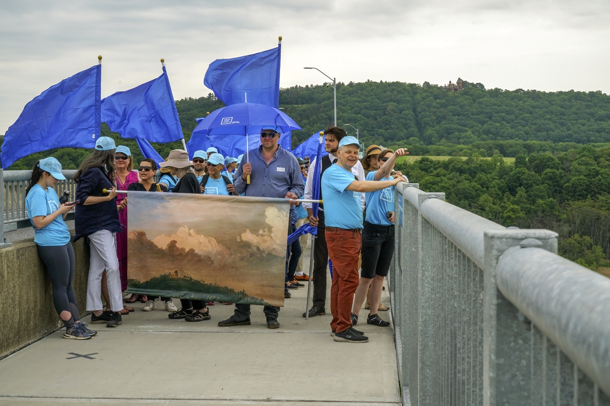
Marchers with Church’s “Clouds Over Olana,” painted 1872, and the house in the distance

The occasion was the opening of the Skywalk, a new pedestrian walkway that connects the artists’ homes and creates a unique cultural bridge, continuing an artistic conversation that began in the early 1840s when Church became Cole’s only pupil. Many years later, after he had become one of the most famous painters in the world and long after his teacher’s death in 1848, Church acquired the mountaintop land just outside the town of Hudson, hired the architect Calvert Vaux, and built the house that would look out – and also down – on Cole’s property across the river.  The Rip Van Winkle Bridge is a stunningly beautiful perch that puts this quintessentially American landscape on view: mountains, river, valley, railroad.

Marchers from the Thomas Cole house crossing the bridge

Yes, the Skywalk is 100 miles north of the High Line, but its mandate is much the same: to use its bridge-like infrastructure to create a linear cultural experience, linking the past to the present through art, design, and landscape, all courtesy of a relatively new American tradition of adaptive reuse that we can all be proud of.

It’s a big week for bridges: the Skywalk opens June 1, and the High Line’s Tenth Avenue Spur, the final section of the park, opens this Tuesday, June 4, after many years of planning and preparation.

What a great week for walking in New York State.

Share
{ 0 comments }

The Funny Thing About Landfill

These guys are swimming on land. Or, more precisely, on landfill.

Workers in the Hudson River on 50th Street

Men working in the Hudson River/59th Street

And, on an unseasonably warm December day, they seemed to be enjoying themselves as they went about their business repairing giant piles that help support a roadway that’s shared (and not always so nicely) by joggers, bikers, bladers, pedestrians, baby strollers, cars and giant garbage trucks on West 59th Street. Let me illustrate this spot a bit more clearly:

West 59th Street, courtesy Google Maps

West 59th Street, courtesy Google Maps

I was riding my bike downtown when I stopped to see what was going on.  After being told about the pile repair, I remarked that we humans are re-asserting our claim to this patch of “land” once occupied by the Hudson River. One of the workers replied that the Hudson River was actually the one doing the reclaiming. It was, after all, part of its watery domain before we came along and started filling in the edge of our prosperous island. Have another look at the same spot, courtesy of Oasis, the mapping organization that works in cooperation with the Center for Urban Research at CUNY to provide the richest source of community maps for New York City (as always, click an image to enlarge it):

Manhattan Island with the 1609 shoreline. Courtesy of Oasis & the Mannahatta Project.

Manhattan Island with the 1609 shoreline. Courtesy of Oasis & the Mannahatta Project.

[continue reading…]

Share
{ 0 comments }

A River Runs Through It

Sandy's high water mark, 22nd Street near 11th Ave.

Hurricane Sandy’s high water mark. West 22nd Street, near 11th Ave.

When I was researching my High Line book I came across an autobiography published in 1864 by a professor at General Theological Seminary, Rev. Samuel H. Turner. In his book Dr. Turner recalls the days when there was a hill and an apple orchard behind the Seminary, and 21st Street was known as Love Lane. There was also, running north along the western edge of General Theological Seminary, something that would surprise a modern visitor. The Hudson River.

The city was just a bit smaller in those pre-landfill days, and Dr. Turner describes how, at high tide, the river “washed what is now the Tenth Avenue.” The Hudson presented many challenges to the Seminary community, including depositing at its front door waves of mud that was ankle deep. One winter, so much mud piled up around the building that “it was almost inaccessible, except on horseback or in a carriage.”

Rev. Samuel H. Turner

Rev. Samuel H. Turner

These days, as I walk down 22nd Street toward the West Side Highway, I find myself thinking about Dr. Turner and his mud problems. You have to look carefully, but there, running along several buildings on the north side of the street, is Hurricane Sandy’s high water mark.  Flecked with mud and grime, the crusty water line is an inch or so thick and stands about 5′ above the sidewalk.

No one has yet come to wipe this reminder away, though it crosses several properties. Here, on a spot where 200 years ago Samuel Turner and his colleagues would have seen whitecaps and sailing masts, is a strip of dirt from the deep caverns of our ancient riverbed. Sandy’s water line stands as an enduring, muddy cicatrice that marks the spot where briny waves of the Hudson River stormed past a restaurant, a furniture maker’s shop, a few art galleries, a city-run shelter for men, and some homes on the evening of October 29th.

After the Civil War the city began selling “water lots,” and developers rushed in to buy up chunks of the Hudson River, which they filled in and developed into factories, warehouses, and living quarters for the surging immigrant population that was flooding New York. The building where I live, which hugs the High Line east of Sandy’s water line on 22nd Street, was built in 1888 as a cigarette packing factory. Later it became a furniture factory for a company called Spears, which cut giant window bays into the brick walls and attached a loading dock that connected to the High Line, thus facilitating the shipment of furniture along the New York Central Railroad’s elevated freight line.

The High Line roughly follows the landfill line on the far west side of Manhattan. I’m pretty sure this is why the cabinets in my office started rattling and tilting during the freak earthquake of August 2011, while friends who were working on good old Manhattan schist in midtown felt nothing. Back in the early 19th century there was a river running beneath us.  Eager developers mastered some part of that river and built upon it what was first a center of industry and later became a magnet for artists, geeks, hedge fund guys and tourists. But what we now know, courtesy of Hurricane Sandy, is that this river will rise up from time to time and leave its watery mark on our real estate and on our lives.

No horse, no carriage, no automobile will ever be a match for the force that came through here two months ago.

Share
{ 1 comment }

Sandy and the Bald Eagles

During the last major storm, Hurricane Irene, a group of us hunkered down on this small mountaintop in Hudson, New York and were transfixed by a sailboat that had moored in the inlet near Roger Island, a tiny spit of land just a stone’s — or piece of railroad ballast — throw from the Amtrak tracks heading north to Albany and south to Manhattan.

Today, a year later, a new storm bears down on us. The sailboat has found another port of safety but we are again transfixed by Roger Island. A bald eagle and its mate are hopping from nest to tree, surveying the landscape, perhaps assessing the changes that are coming our way. The river has tossed up a slew of whitecaps and the wind is getting stronger. With my telescope I can see the feathers on the eagle’s tail blowing in the wind. In the photo above, taken with a telephoto lens, you can just make out a tiny white head in the tree, 2,500 feet to the west, and the massive nest just to the south (left).

What does the eagle see? What does he know about the oncoming storm? Will his nest hold up in 75 mile per hour winds?

I think about a villanelle by W.H. Auden.

Time can nothing but I told you so.
Time only knows the price we have to pay;
If I could tell you, I would let you know.

Good luck, Eagles.

Share
{ 0 comments }

The Falcon and the DEA Man

Peregrine Falcon Departs from the DEA Building

If you’re a regular High Line visitor you know the magnificent peregrine falcon who has taken up residence at the Drug Enforcement Agency building on 17th Street. I’ve been photographing this bird for more than a year, and a few months ago saw him perched with his mate.  Occasionally he cries out in piercing bursts, but lately he’s been sitting very quietly for hours at a time, watching the world go by. Today I caught him leaping off his ledge to go soaring over the Hudson River.

The Hudson is a major migratory corridor and some 300 species of birds – songbirds, raptors, waterfowl, shorebirds – pass overhead each year. One reason the abandoned rail line became such a bountiful wild garden is because birds carried seeds here from all over the country, both on their feathers and in their droppings. In his plan for the High Line landscape designer Piet Oudolf included many of the prairie grasses and perennials that first came here courtesy of birds.

The Spring Cutback

My theory is that the falcon is transfixed, as so many of us are, by the Spring Cutback, a great event that brings dozens of volunteers to the High Line to cut back all those perennials and grasses and allow for new growth.

There are 100,000 perennials and grasses in the park, but unlike many gardens, the plants are not deadheaded in the fall. An essential aspect of Oudolf’s planting design is the presence of seed heads in winter, and these dried, multi-form structures play an important role in the distinctive High Line landscape. The untouched plants also provide food and habitat for wildlife throughout the winter. But every year, beginning in March, it all has to be cut back.

There’s so much to see along the High Line right now — it’s an embarrassment of riches. Just don’t forget to look up as you walk south through the Chelsea Grasslands. You might catch that wonderful bird watching you.


Share
{ 1 comment }

Stephen Vitiello’s Bells From the Hudson River

Today is the first day of the Atlantic hurricane season, and this afternoon New York City was under a tornado watch. This made me think about a story I read about the Frying Pan lightship that’s docked at Pier 66a just a few blocks from my home and in view (I think, but won’t know for sure until next week when section 2 opens) of the High Line.

The Frying Pan was stationed at Frying Pan Shoals, 30 miles off Cape Fear in North Carolina. The boat, a lightship, was designed to be a floating lighthouse that would guard other ships and help them avoid running aground on shoals or submerged rocks. On the Frying Pan’s website you can read an account by a former captain of how the anemometer was literally blown away by Hurricane Donna. The boat and crew withstood 50 foot waves and a roll of 70 degrees. Someone else on the website describes life on the Frying Pan — which was launched just a few years before the elevated railroad we know today as the High Line opened for business — as “filled with months of boredom followed by minutes of pure fear.”

For a short time — until June 20th — you can hear the Pier 66 Maritime bell at 31 minutes past the hour, every hour, in the 14th Street Passage of the High Line. It’s part of Stephen Vitiello’s wonderful “A Bell for Every Minute” exhibit which I am so sad to remind you will close later this month. Get there a bit early and you can hear the bell of the noble John J. Harvey, a retired NYFD fireboat that steamed down to lower Manhattan on September 11th, 2001, to try to help put out the fires at the World Trade Center; the Harvey assisted the NYFD in evacuations and then returned to pump water from the Hudson River because the water mains downtown had been damaged by the terrorist attacks. That boat has a stately history too, which you can read about at fireboat.org.

So much New York-ness, present and historical, to be heard in Vitiello’s exhibit. Get there while you can; once it comes down it’ll be gone for good and won’t exist in any form on the web. The pdf of Vitiello’s “sound map” is here and won’t go away, but it’s silent. The bells are glorious. I wish they would become a permanent part of the High Line.

Share
{ 0 comments }

The River That Flows Both Ways

The art exhibit by Spencer Finch, “The River That Flows Both Ways,” is one of my favorite parts of the High Line and today I discovered something I hadn’t noticed before. Again, I thank the camera, which caught something my eyes didn’t see on their own: the reflection of the building just opposite the colored glass windows.

One of the things I love about the High Line is the multitude of windows you see while walking along, everything from cracked, bricked-up windows with bullet-holes on old industrial buildings to the undulating curves of the IAC building. And in the Standard Hotel there’s a “window” cut in the eastern footing of the building that looks onto other windows: Windows on windows. So I shouldn’t have been surprised to see the reflection of yet more windows in Spencer Fitch’s exhibit.

Another thing I admire about “The River That Flows Both Ways” is the fact that every time I photograph it it looks different. Just like the river itself it can’t be nailed down. It keeps changing depending on how the light is falling, where you’re standing, what time of day it is, what season of year, and what the weather is like.  I find the changeableness of this exhibit oddly comforting because it’s so perfectly reliable.

The Algonkins, the people who first settled in New York Harbor, named what we now call the Hudson (after the English sea captain) “the river that flows both ways.” They were stunned when they first saw it, a river with currents that flow north and south at the same time. You can see it yourself; just stand on a pier or lean up against a railing along the Greenway. I’ve never seen anything like it anywhere else; it’s just fascinating and confounding.

That’s what Spencer Finch’s exhibit captures: the movement and changing patterns of this great river. You can read about his project here, and see a photo that looks nothing like mine.  I hope the High Line folks make this wonderful exhibit a permanent feature of the park.

Share
{ 0 comments }